Friday, May 31, 2013

ET Phone Home

We drove the Extraterrestial Highway, stopping at Rachel, NV for lunch.  The ET Highway goes through an area in Nevada where Nellis Air Force Range is located.  The land adjacent to the highway is referred to as Area 51.  Historically, there have been several 'alleged' unidentified object sightings and alien abductions.  We were unable to see the military base from the ET Highway by Groom Lake.  There are thousands of stories and a great bit of mystery surrounding this area in Nevada.  The short version is that the Federal Government has tried for years to cover up the fact that we (the U.S. Government) have in our possession the actual bodies of aliens and their ships.  You could say Jerry and I are "into the possibilities," and we have watched a number of documentaries supporting that Area 51 is one of many locations around the world where alien ships and aliens have been sighted. 

Whether you believe or not, a day's drive on the ET Highway is a great time to consider the possibilities for fun.  When we turned onto the highway, this replica of an alien in full silver suit was the first thing we saw.

Those few - and I do mean few - who live along the highway have joined the spirit of possibilities that we are not the only beings in this or other universes. 

Let's just suppose for a minute that aliens do exist, and chose this stretch of highway to "study us" through abduction.  Said aliens would have a very slim choice of humans.  The ET Highway at 100 miles has at most 20 people who live along the road.  The town of Rachel, NV is about 50 miles from Junction 93 where you turn on the ET Highway.  There is a very small motel and restaurant / bar in Rachel, and there are maybe two houses.  The population sign entering Rachel says, "Population: People - yes, Aliens - ?" 

Rachel, Nevada
The front of the restaurant sports this late '40's truck with a very small spaceship hanging from the crane.  We had a great sandwich at the restaurant and spent time looking at the picture documentation of alien sightings from all over the western hemisphere.  Of the two people who work in the restaurant, we were unable to confirm either had ever had an alien encounter.

We continued on the ET Highway headed west.  We saw few cars on the road, and fewer houses.  The mountains in front of us seemed to move further away from us as we drove.  The ET Highway went on forever.

Extraterrestial Highway, Area 51, Nevada
Given the landscape of open space, few humans, and the haze of sun that seemed to hang over the entire landscape, it wasn't hard to believe the imagination could take charge.   Although we weren't on the ET Highway at night, we imagined the total darkness and clear skies and possibly a spaceship or two in the night skies.

Our journey on the ET Highway ended at Highway 6 where we headed west toward a town called Tonopah, NV, and old mining town, which is just east of the California boarder.  We spent a quiet night in the parking lot of the Banc Casino. 

The next morning, up early, we headed for Yosemite National Park.  Our entry to CA was marked by an amazing line of mountains.  Yes, that's snow.  As we turned north off Highway 6 onto north 395, we found ourselves in the Mono Basin.


The Basin, and Mono Lake, is an area formed from volcanic eruptions millions of years ago.  The area is full of pumice and obsidian.  The lake bottom has tufu spires, some of which top the water surface.  The lake has many natural springs that go into it, but none that go out.  Water levels do go down due to evaporation.  The water is 7 times more salty and alkaline than the ocean. 


Mono Lake
We stopped for the night in a small campground in Lee Vining, CA.  The campground is literally snuggled up next to a mountain, and our campsite looks out over Lake Mono.  A short walk to town for supper will be the highlight of the evening.  Then an early start to head for Yosemite National Park.  Although we do not plan to stay in the park, we want to have plenty of time to explore and take our time before heading further west to San Jose, CA.

Thursday, May 30, 2013

The North Rim

Seven years ago we traveled west.  At the top of our list of places to see was the North Rim of the Grand Canyon.  This was the second attempt, since an early snow and ice prevented us from traveling to the NR a couple years before that.  As we neared the North Rim in 2006 we could see large areas of smoke on both sides of the highway 89A, and we could see firefighters in action.  When we got to Jacob's Lake, which is where 67 goes down to the Rim, the firefighters were staging with fire engines and personnel.  We would not see the North Rim that day.


The fire is referred to as the Fire of 2006.  Almost seven years later, the forest ravaged by this fire still stands scorched.  The undercover has barely started to recover.  As we drove the road down to the North Rim of the Grand Canyon, we saw miles and miles of scorched land.  Burnt trees had been cut down nearest the road in order to prevent falling timber weakened by fire.  This day we were particularly grateful as the wind was gusting up to 40 mph. 


 We continued our trek to the Grand Canyon, and as we drove the landscape became greener and more plush.  I know little about the patterns of raging forest fires, but on that day in 2006 the fire would not destroy every mile - I'm sure in part to the incredible efforts and expertise of the people who fought the fire.

As we drove higher in elevation, we caught glimpses of the canyon through the trees.  We knew we would round a curve and eventually get a full view.  I felt a sense of anticipation like a little kid waiting to open a present.

Normally, I would be the passenger so distracted by all this incredible landscape, but this day I was the driver.  Jerry had driven the Whale through mountains and very narrow roads the day before.  We decided to give him a break.  So I drove the Jeep down to the North Rim.  Once we climbed in elevation, given I am deathly afraid of heights, I thought maybe this was not such a good idea.  We did make it to the North Rim without driving over the edge.  The roads there have few guardrails as the natural beauty has been preserved without distraction. 


 We were not disappointed when we came in full view of the Grand Canyon.  From one vantage point on a path around the base of the North Rim Lodge, everywhere we turned was an overwhelming view.  The magnitude of the Grand Canyon is hard to comprehend even when a person is looking right at it.  The human eye can only see so far.  I knew there was more canyon further than I could see, yet still it's hard to really grasp it.
We traveled in the Jeep to the highest point further around one point of the canyon for just one more look before leaving the Grand Canyon National Park.  Since Maci had been in the Jeep for quite some time, we thought this would be a good time to stretch her legs.  At about 8,800 ft elevation, she jumped out of the back seat and right back into the front seat.  The dog's mind is a mystery to me...  She either did not care for the elevation or the gusts of wind at this elevation.  Standing on the edge of this high point was somewhat intimidating. 

"Dimension means nothing to the senses and all we are left is a troubled sense of immensity."  Geologist Clarence Dutton, 1889

We said good-by to the North Rim the next day to continue west through Zion National Park.  All vehicles larger than a passenger car had to pull off the road before the park to read and confirm size restrictions.  Vehicles longer than 50 ft. are not allowed.  Vehicles taller than 13'1" can't get through the tunnels.  We met the height limit at 12'7", but length?  Let's see...  40 foot of Whale + tow bars + Jeep = more than 50 ft.  We had to unhook, and I followed Jerry in the Jeep.  We have navigated some pretty tight curves with the full rig, but once we got into Zion, I fully understood the need to not be longer than 50 ft.  Those are some tight switch-backs!  There are also two tunnels - the first can be driven without problem.  The second tunnel requires stopping all traffic for "over sized vehicles" so the driver can drive down the middle of the tunnel avoiding getting stuck. 

This shot of the Whale from a safe vantage point behind gives you an idea of the incredible landscape in Zion National Park...  although I do suppose shooting pictures while driving a mountain road is much like texting and driving.

Since parking the Whale requires quite a bit of space, many of the pull-offs were too small. We finally made our way to the South Campground where we were able to hook up and continue our drive west. 

We stopped at Young's Campground, a very small camp with full hook-up in Caliente, NV.  The owners were welcoming and thanked us for stopping.

We're now headed to the Extraterrestial Highway and Area 51 which as I have said before does not officially exist according to the Federal Government.  Since aliens are not for abductions in the day, we anticipate traveling this highway without incident... 

Tuesday, May 28, 2013

Westward Ho!

After leaving Ft. Worth, TX, we traveled to Hobbs, NM and on to Santa Fe.  Our target destination was the state park outside Santa Fe at the edge of the Santa Fe National Forrest.  Once we arrived we realized there were no campsites big enough for the Whale.  Nor were there any spaces wide enough to turn the Whale with Jeep around.  So we continued up the mountain - 10,000 feet to the ski resort at the top of the mountain, turned around, and crept back down the mountain.  A quick stop at the scenic view pull-off on this clear day gave us picture reminders of just how high we were.  If you look at the bottom of the first picture, you can see a sliver of the road dropping off down the mountain.  That's steep!  Jerry says the trick is to not let the Whale go to fast and at the same time don't get on the brakes too often.  How would I know?  I had my eyes closed.

 Once we were down around 8,000 ft we secured a spot for the Whale in the National Forrest Campground just south of the State Park.  No hook ups, but a beautiful spot. I again had a new experience in this location - altitude  sickness. Ugh!  The least little bit of exertion made breathing difficult.  Of course I went to the Internet for diagnosis and solution - go to a lower altitude... duh.  We did that the next day spending most of our time in Santa Fe.  What a unique city.  We had lunch at the Blue Chip and dinner at La Choza.  Both meals gave us a chance to experience local cuisine.
Santa Fe National Forrest, NM... on top of the world.

Our time in Santa Fe was too short, and the area is now on our list of places to return.  I was particularly drawn to the adobe structures - which most are.  Both color and form blend into the landscape around Santa Fe.  Our time in the downtown area showed us more of the same.  Fortunately, we had too little time to stop and wander the shops in the downtown area...  I probably saved a lot of money. 

After two days in Santa Fe, we continued west on 264 avoiding the Interstates for now.  We stopped for the night at the Hopi Cultural Center just west of Keames Canyon.  An overnight stay turned into 2 1/2 days.  Luck would have it that we met another full time couple while at the Cultural Center while walking our dogs.  Sandy and Orlan had scheduled a tour with a Hopi guide the next day and invited us to join them.  Bertrand met us the next morning, and we traveled to our first stop - the Prophesy Rock.  Bertrand detailed the meanings of the petroglyth which was thousands of years old predicting the future - some of which has already come to pass.

Bertrand was a wealth of knowledge not only about the Hopi culture, past and present, but he also made multiple connections between other cultures and his ancient culture.  Interestingly, he spent the first seven years of his life with his mother and father in an urban area in southern CA.  He returned to his native village Old Oraibi with his mother at age seven.  He admitted this was quite a culture shock, but the move was ultimately for the better.  He is now working his way toward the "man society" as he gains knowledge and continues to share his culture with visitors to the area.  The Hopi in this process are the ultimate life long learners.  They believe no one ever knows everything.  The elders disperse knowledge to the younger men a little at a time in keeping with this philosophy.

Bertrand then took us to the other side of the Second Mesa to his home village, Old Oraibi.  We were restricted from taking pictures of the village, and we were only able to visit a small portion of the village.  We did get to see the central area of the village where the kiva was located.  This kiva, or ceremonial lodge, was underground.  There was a large ladder made out of tree trunks that gave access to the kiva.  We were not allowed access to that area for understandable reasons.  In the early 1900's photographers were allowed access to ceremonial proceedings and areas, and it become very clear to the Hopi people that if continued, they would be invaded.  Around this time, restrictions were put in place.  In my mind, how wise the Hopis were to restrict photographs and observations.  They have been able to preserve some of the deepest meanings of their ways. 

From the village we walked a ways across the top of the mesa to an area where there were many petroglyths along a pathway that winds around the upper portion of the mesa.  We were allowed to take pictures here.  As you can see, the pictures show the striking contrast of stone and sky, but do not do justice to the petroglyths that have survived centuries. 


It's not too hard to imagine the Hopi living in the caves of these areas even before villages were constructed.  The elevation of the mesas served as protection against invaders.  As our guide explained, the Hopi's are not aggressive people.  They do believe in peace, but were not afraid to defend themselves when necessary


We walked the path around the top of the mesa.  I have to say that my fear of heights was diminished by the sheer striking beauty of the landscape...  and a good solid rock to hang onto.
 Once we left the mesa and returned to the village, we were able to step inside a dwelling that served two purposes.  It was there to give us a glimpse of what the inside of the original structures looked like, and it was also a gift shop showcasing the jewelry and pottery of the Hopi artisans.  Again, we were unable to capture this in pictures. 

It's important to note that across all three mesas in the Hopi Land, people do reside in the villages.  Those in Old Oraibi do not have electricity as in poles and wires, but some use solar power.  There is no running water or toilets as we know it.  The fifteen or so families who still live in the village practice the ancient daily job of carrying water from a central location.  This does vary from village to village depending on how that clan has decide to adopt or not adopt different ways.
Our two hour tour turned into four hours.  Exhausted and overwhelmed with information, we said good-by to Bertrand with promises to send curious visitors his way.  We returned to the Cultural Center and decided to stay one more evening.  We left the next day after purchasing artifacts from the artisans who had set up tables outside the center.

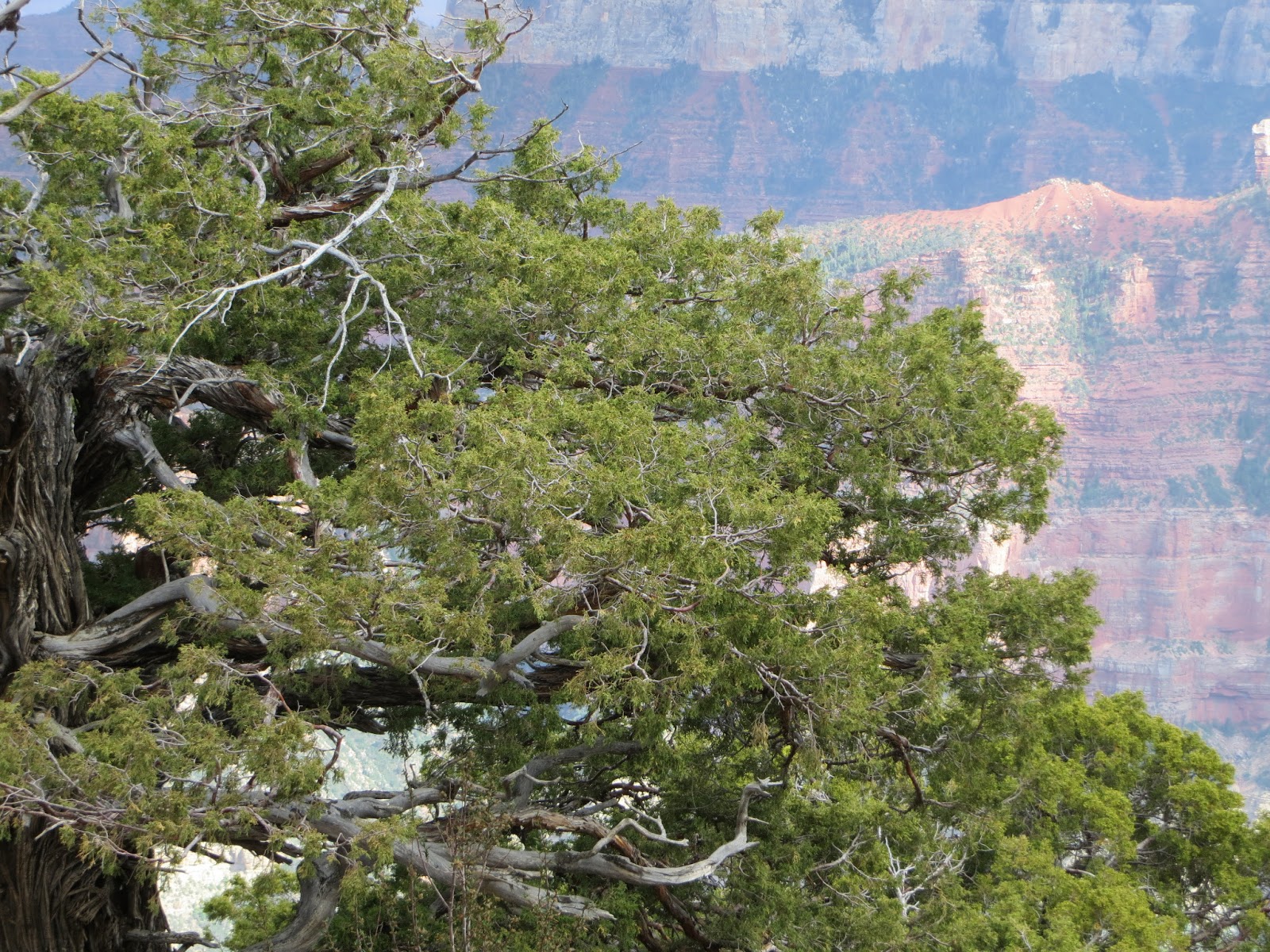
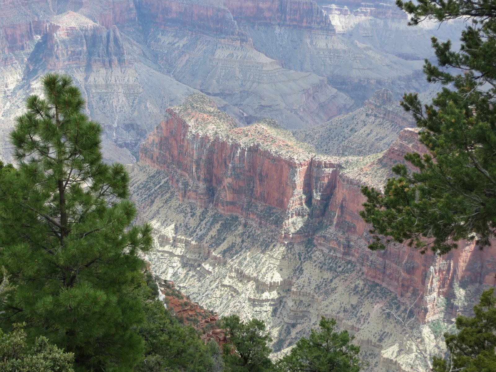
We now are in a state forest campground just north of the North Rim, Grand Canyon.  The whale was able to climb yet another mountain as you can see below. 

The Whale on the road to the North Rim
A word from Maci...  You know dogs really don't like change, but it's something I have become accustomed to in order to be with my people.  I ride on the couch now, much more comfortable than the floor unless the going gets bumpy.  I prefer parks over parking lots, and I certainly prefer grass over dirt.  Sometimes I just refuse to get out of the Whale.  As long as I can keep any eye on things from the inside, I am good to go.  What an adventure this is!

Maci keeping watch from the drivers seat.


Monday, May 20, 2013

400 Mile Detour

One of the best parts of this journey is having the flexibility to make detours when necessary.  Luck would have it that my brother Ted was making a "quick" trip from Michigan to Fort Worth, TX to deliver a hand crafted rocking horse to a very dear little girl, Jewel, who is the granddaughter of his close friends, Greg and Colleen.  We were in London, AR when we found out he would make the trip, and we decided to take just  slight detour to Fort Worth in order to spend time.  We chose an Army Corps of Engineers camp just south west of Fort Worth, Holiday Campground on Benbrook Lake. We secured a camp site in a more isolated part of the park, with tons of shade trees.  The time here has been quiet, windy, hot, and did I mention windy?

We also were blessed to prepare dinner for Ted, along with Greg and Colleen as well as their son John, daughter-in-law Jennifer, and the new owner of the rocking horse, Jewel.  It was instant family! We have been in need of a heavy dose of family.  It was great!!

Our last day on Benbrook Lake has been the windiest of all.  We had been told by other travelers Texas tends to be windy.  We've only been in a small portion of a large state, but the last four days have made a believer of me.  The dory, now officially named "Sweet Pea," stayed on top of the Jeep.  We know the limitations of a little boat on a lake with lots of white caps...  We did get in long walks every day.  The park is full of fields of wild flowers.  Maci clearly loves the parks over the parking lots at Wal-Mart.  She has her happy pant on.
                                                                                             We head northwest tomorrow a.m. headed to Roswell, NM.  We plan to drive the Extraterrestrial Highway through Area 51 - which doesn't officially exist according to the Federal Government.  Usually I don't post until after we have visited an area, but since we are going to a part of the country where so many Alien sightings and abductions have been noted, we thought it best to file a "flight plan."  Seriously?  We'll see...

Thursday, May 16, 2013

Before we left Red Bay...

You would think after a couple of visits to Red Bay, a very small community, there would not be much more to see.  Not so.  There is a cemetery at the very top of a hill near Red Bay called Coon Dog Cemetery.  What an interesting name for a cemetery.  It seems the name is totally accurate because the cemetery is where some bury their prized coon dogs.  Like most dog owners, the dog is an integral part of the family.  Some have more specific skills than others.  Some dogs are just part of the family.  The coon dog is bred to hunt raccoons.  The way the story was told to me is the owners take the dogs into the woods and turn them loose while the humans build a fire, drink some coffee - laced I'm sure - and listen to the dogs bark and bay as they are hunting the raccoons.  According to my source, the dog's bay changes when a raccoon is actually treed.  Then the owners go to the dogs and shoot the raccoon out of the tree.  These are working / hunting dogs that are part of the families who own them, and they are worthy of a burial  plot designated for "Coon Dogs Only."  We spent some time walking around the area, and as you can see by the pictures below each plot has flowers, and most have some type of headstone or marker.  The first dog was buried here in 1937.  From the headstones we read, the dog from furthest away was from Buffalo, New York.  Given the tributes on the markers, there is no doubt how much the dogs meant to their owners.  Some were noted as regional and national champions.
                                                                                                   
 The most recent headstone was March of 2013.  We heard about this funeral.  Over 100 people attended.  The dog was lovingly placed in a small casket, and there were a total of four pall bearers - two human and two hounds.  Yet another glimpse into the minds and hearts of others...


We discovered a new place to eat during this trip to Red Bay.  The Rattlesnake Saloon.  It's always a good idea to get out, walk around and socialize when you're waiting for service in Red Bay.  That's the only way to find out new places to visit.  The Rattlesnake Saloon is northeast of Red Bay off of Highway 24 way in the middle of nowhere.  The saloon is built in a cave.  The only way to get to the saloon is by riding down a very steep dirt road in the back of a 4x4 pick-up truck that has wooden bench seats down both sides of the bed.  The actual saloon is tucked under a small waterfall on one end of the cave.  Additional seating can be had in the cave amphitheater complete with a small stage for a band or karaoke if you go on Thursday night, or you can sit out in the terraced area.  The saloon lives up to its name with two carved rattlesnakes guarding the front door and several snake skins hanging on the walls of the inside eating area.  If you go, the Rattlesnake Saloon is only open on Thursday, Friday and Saturday.  No alcohol before 5:00 p.m. and only beer after that. 


Monday, May 6, 2013

Monsoon Season in Red Bay, AL

After leaving Three Rivers State Park, we made our way north to Red Bay, Al... AGAIN.  A disabled front furnace and leak in one of the back slides were reason to revisit Red Bay for repairs before heading west to CA.  Returning to Red Bay means we have lots of time to catch up on any in-house duties that need to be done.  It's rained every day since we got here.  Without an "official" appointment, repairs have to wait on "express bay."  There were 10 ahead of us as of last Tuesday,  and we made into express bay today.  With any luck, we'll be headed out of Red Bay by the week-end - that is if we don't drown first.

Three Rivers State Park on Lake Seminole, Sneads, FL

Our last stay in Florida was in the pan handle - Three Rivers State Park on Lake Seminole near Snead, FL.  The lake is a man made reservoir that stretches 20-30 miles.  Marsh areas with reed grass and lily pads skirt the the edges of the lake.  Wide expanses of water barely cover tree stumps that could cause a great deal of damage if a boat hit them with any force.  The water is full of wildlife... including alligators just coming out of hibernation, birds, and fish.  Of the five days we were in the state park, we spent three on the water.  We fished and toured the shores of the lake.  Yes, we fished.  I took up a pole and threw in a line.  Cat fish were on the line.  I now have a "fish that got away" story.  I knew when it hit that it was big.  When I got it close to the boat, Jerry told me it was about 10 to 15 lbs.  Of course we didn't have a fish net.  So when Jerry grabbed the line, the fish was gone in an instant - bit the line.  Better believe we have a fish net now.

Fortunately we caught others that did not get away.  There's not much better than fresh cat fish, fried potatoes and onions, and a campfire.  Five days on Lake Seminole. A great way to end our five month stay in Florida.

Lily Pad Flower

Endless shore...
Red Beaked Bird

Dew that looks like liquid diamonds.

Alligators coming out of hibernation....  Cruising by the boat.